
2025
Comparably’s Best Company Outlook
* Providing engineering services in these locations through SWCA Environmental Consulting & Engineering, Inc., an affiliate of SWCA.

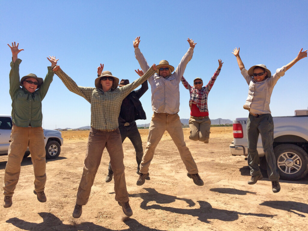
From the experts we hire, to the clients we partner with, our greatest opportunity for success lies in our ability to bring the best team together for every project.
That’s why:
At SWCA, sustainability means balancing humanity’s social, economic, and environmental needs to provide a healthy planet for future generations.
SWCA employs smart, talented, problem-solvers dedicated to our purpose of preserving natural and cultural resources for tomorrow while enabling projects that benefit people today.

At SWCA, you’re not just an employee. You’re an owner. Everyone you work with has a stake in your success, so your hard work pays off – for the clients, for the company, and for your retirement goals.
Mapping a Sustainable Future: Celebrating GIS Day 2025 with SWCA
As GIS Day arrives once again, SWCA celebrates the remarkable technology, dedicated professionals, and transformative impact of Geographic Information Systems (GIS). For over 25 years, GIS Day has united communities, organizations, and innovators worldwide to highlight the power of spatial data in solving real-world challenges.
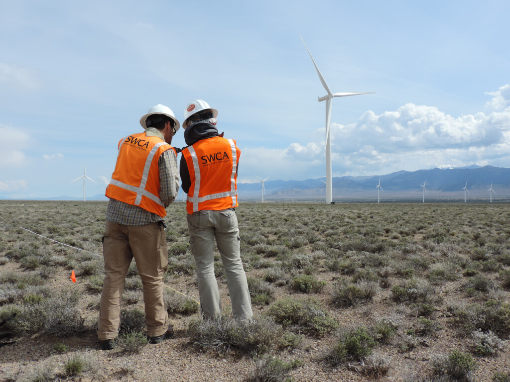
With a team of over 80 GIS professionals and 20,000+ GIS-driven deliverables since 2024, SWCA stands at the forefront of geospatial innovation in environmental consulting. From wildfire protection plans and water resources management to ecosystem restoration and archaeological surveys, our GIS experts turn complex spatial data into actionable insights that make a lasting difference.
“GIS is a core service area that supports all our projects and an important part of our Core Values and North Star. SWCA’s ability to create value and positive impact for the planet and the communities we live, work, and play in, will only be achieved with our GIS team innovating for our clients through project work. #GeographersDoItBetter.” – Joseph J Fluder III, CEO
Our GIS professionals are the architects of sound science and creative solutions. Their work not only advances our projects but also elevates our entire industry, demonstrating that technology, when paired with deep environmental expertise, can solve some of the world’s most pressing issues.
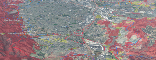
This year, we’re continuing the tradition of our annual Internal Mapping Contest, a crowd favorite that showcases the creativity and technical expertise of our GIS team. Employees are invited to build maps using ArcGIS that address environmental problems and offer new insights or solutions. Whether it’s tracking wildlife migration, mapping rising sea levels, or managing natural resources, these maps are a testament to the transformative potential of spatial analysis. We can’t wait to see the innovative maps our team will create this year.
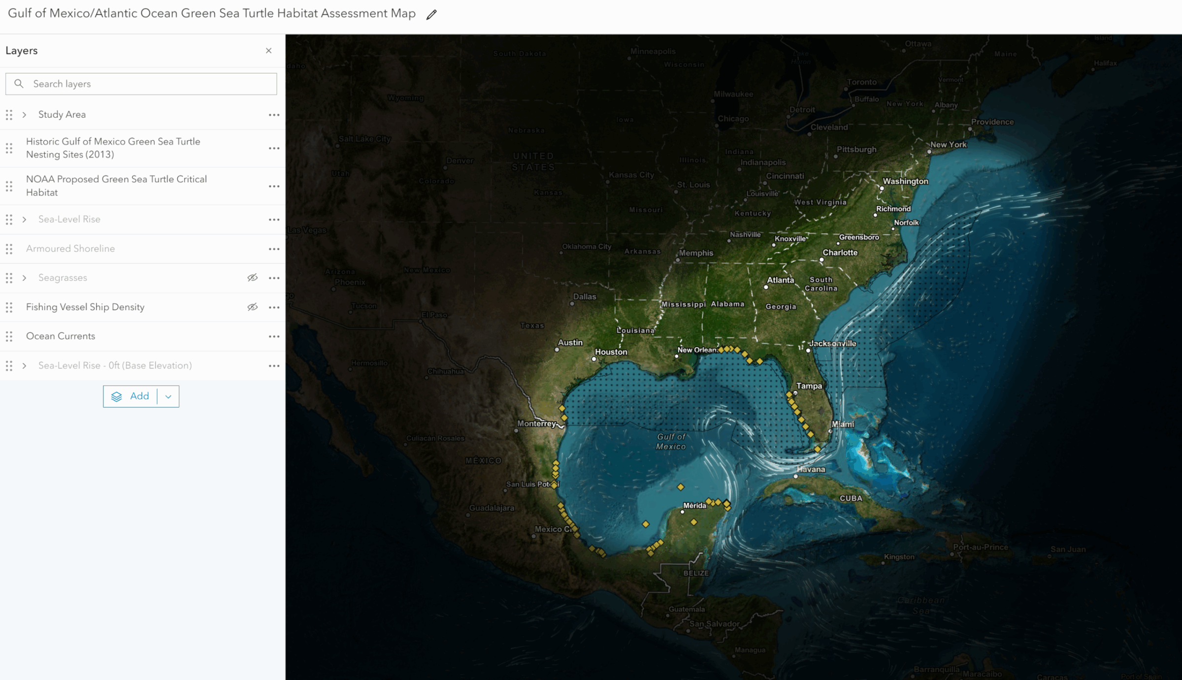
Sean McKinney’s winning map was created to analyze green sea turtle habitat environmental risk factors. It demonstrates the man-made development of shorelines, commercial fishing, and degradation of seagrass and underwater vegetation pose a threat to natural sea turtle habitats, while sea-level rise can reduce potential habitats areas over time.
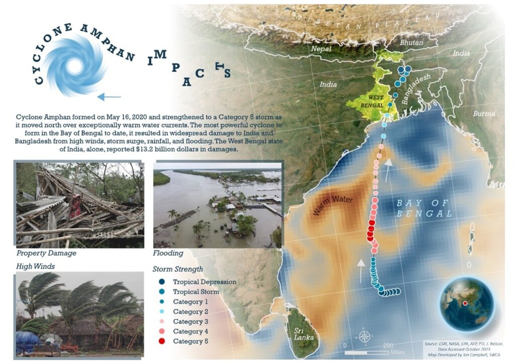
Jon Campbell’s map showcases the impact of Cyclone Amphan on India and Bangladesh that formed in May of 2020.
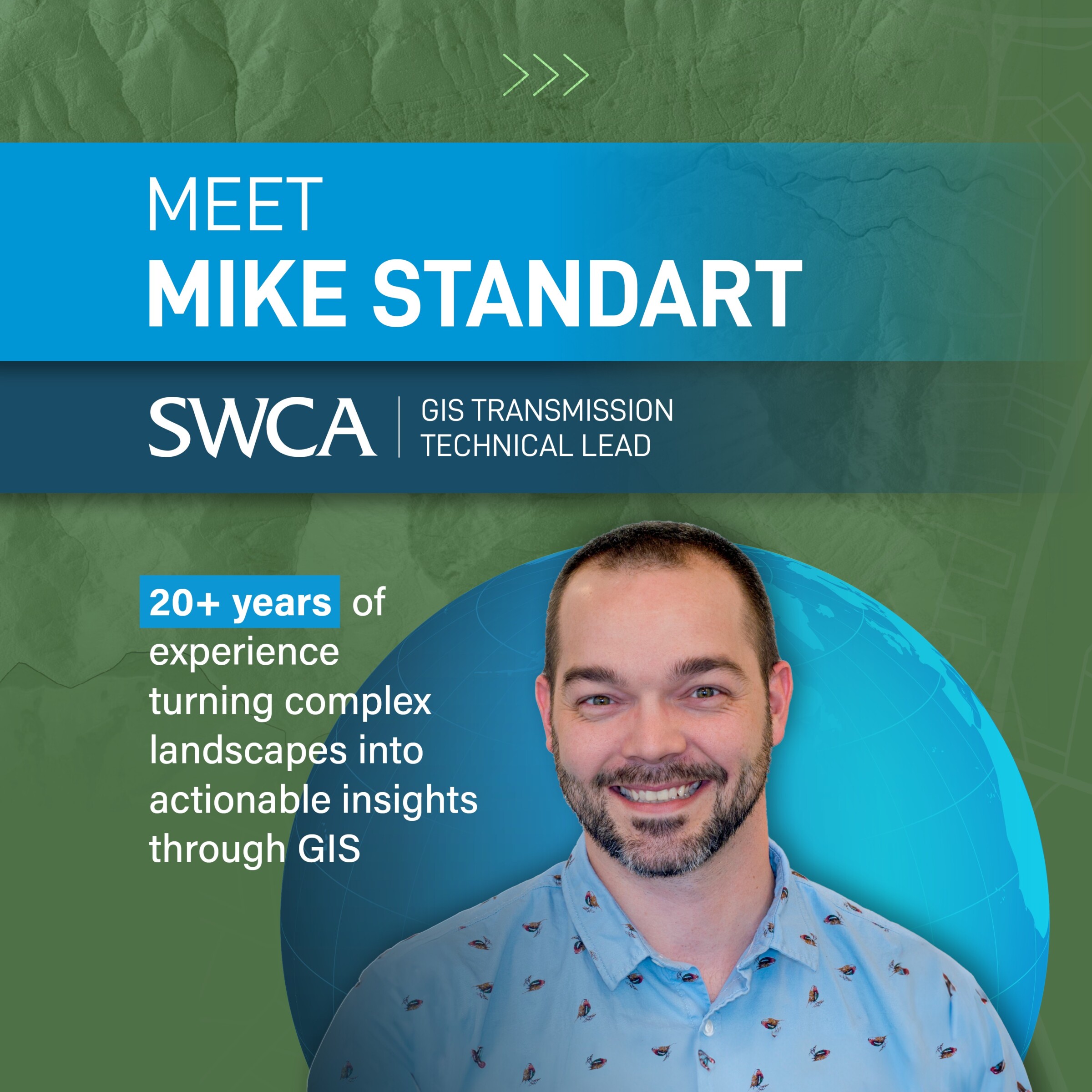 Meet Mike Standart, SWCA’s Transmission Siting Lead. Mike’s GIS journey began in college, drawn by the blend of technology, science, and visual arts. Early work digitizing transmission infrastructure led him to specialize in transmission routing and siting.
At SWCA, Mike collaborates with a diverse team to develop innovative GIS tools for complex infrastructure projects. His process integrates 40–50 data layers, combining local and national datasets to identify the best routes while balancing engineering, environmental, and community needs.
Transparency and stakeholder engagement are central to Mike’s approach. He uses web maps and story maps to make GIS data accessible, allowing clients and communities to provide feedback and see their input reflected in project decisions.
“Community input is vital for successful siting projects. We create public web maps where people can submit comments and see how their feedback leads to real changes. When the community is engaged, projects are stronger and more resilient.”
Looking ahead, Mike is excited about SWCA’s dedicated GIS transmission team and the opportunities to innovate as energy demands grow. His advice for newcomers:
“Learn everything you can, seize every opportunity, and connect with mentors—you never know where it might lead.”
Mike’s career journey exemplifies how GIS and teamwork are shaping the future of sustainable infrastructure at SWCA.
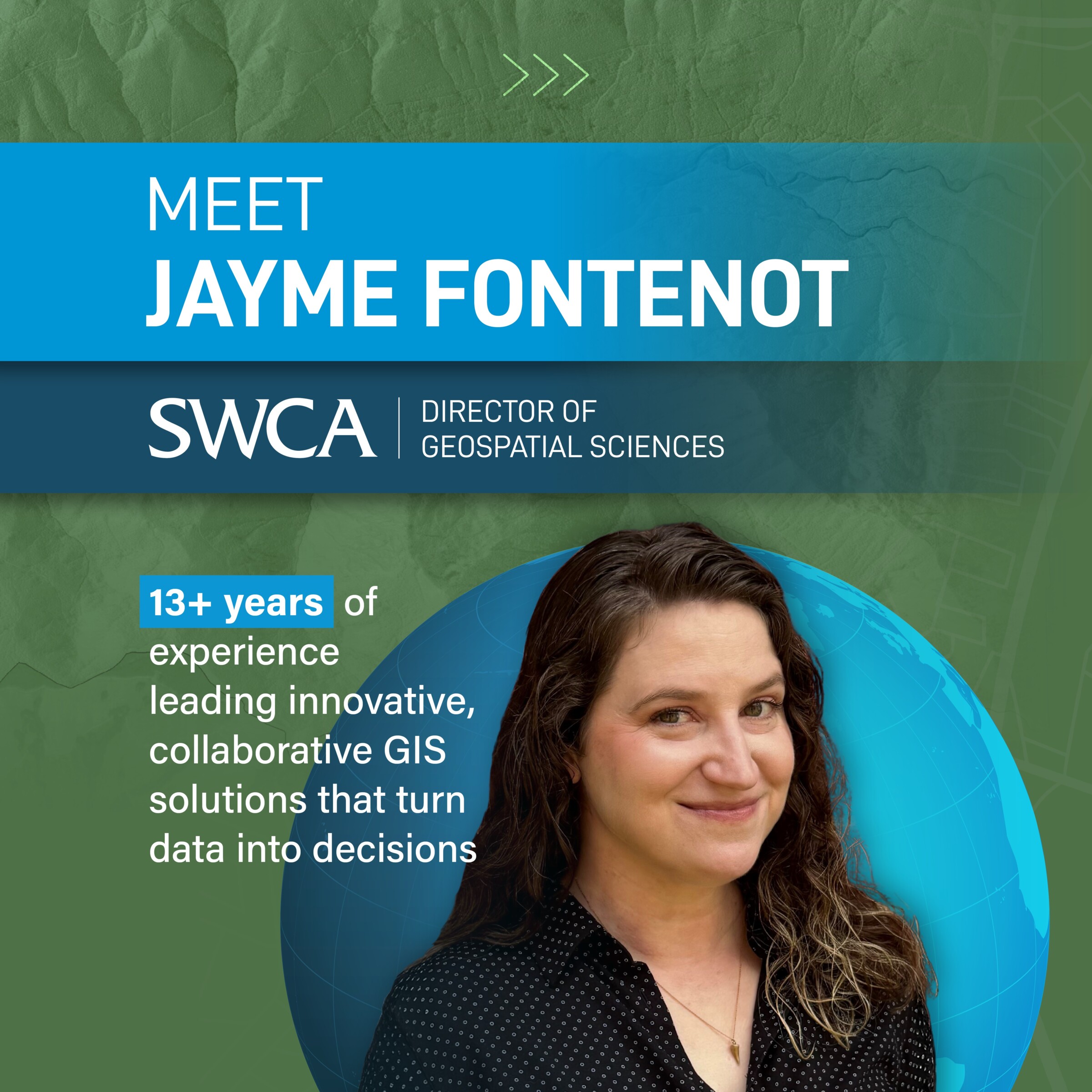 Meet Jayme Fontenot, SWCA’s Director of GIS, whose 13-year journey at the company is a testament to following your gut, embracing new opportunities, and growing alongside technology. Jayme joined SWCA in 2012 after earning a master’s degree in biology—initially with no idea what environmental consulting was. A chance connection with a project manager led to a temp field role in Arlington, Texas, where the culture immediately stood out.
“I chose SWCA based on vibes and the people I met,” she recalls. “Thirteen years later, I don’t regret it for a second.”
While her academic background was in biology, studying reptiles and amphibians in disturbed landscapes, it was GIS that allowed her to map movement patterns and visualize ecological data. What started as a “backup skill” quickly became her career path. She brought her GIS certification to SWCA, pitching herself as both a field tech and a budding GIS professional. Eventually, she transitioned full time into GIS, training alongside colleagues in Houston and eventually becoming the only GIS specialist for Arlington and Oklahoma.
Her field experience remains central to how she leads GIS today:
“Understanding what field staff go through—working in 100-degree heat, trying to keep equipment running, collecting data in challenging conditions—completely shaped how I approach GIS. It reminds me to give grace, build tools that make sense in the real world, and make sure field data tells the full story.”
Jayme’s advice to those entering the field: take it seriously and embrace its versatility.
“GIS is no longer a side skill—it’s a legitimate discipline with dedicated training and a huge range of applications. But it’s also creative. There are a million ways to solve a problem with GIS, and that’s what makes it exciting.”
SWCA is proud to offer a dynamic environment for GIS professionals at every stage of their careers. With roles ranging from internships to advanced leadership positions, there’s an endless opportunity to grow, innovate, and make a difference.
The GIS team at SWCA is a real strength. We employ a capable, collaborative, and well-integrated team of GIS experts who provide a wide array of geospatial services and deliverables for internal planning, field teams, reporting, and client use.” — Jon Campbell, Senior Geospatial Analyst
Whether you’re a GIS professional, a student, or simply passionate about the environment, join us in celebrating the impact of GIS and the people behind it. Here are five easy ways to mark the occasion:
As we celebrate GIS Day 2025, we recognize the people, technology, and sound science that make SWCA a leader in environmental consulting. Our GIS team’s passion and expertise are shaping a more sustainable world—one map, one project, one solution at a time.
Join us in celebrating GIS Day 2025 and discover how SWCA’s unique approach to geospatial science is driving creative solutions for a better tomorrow.